
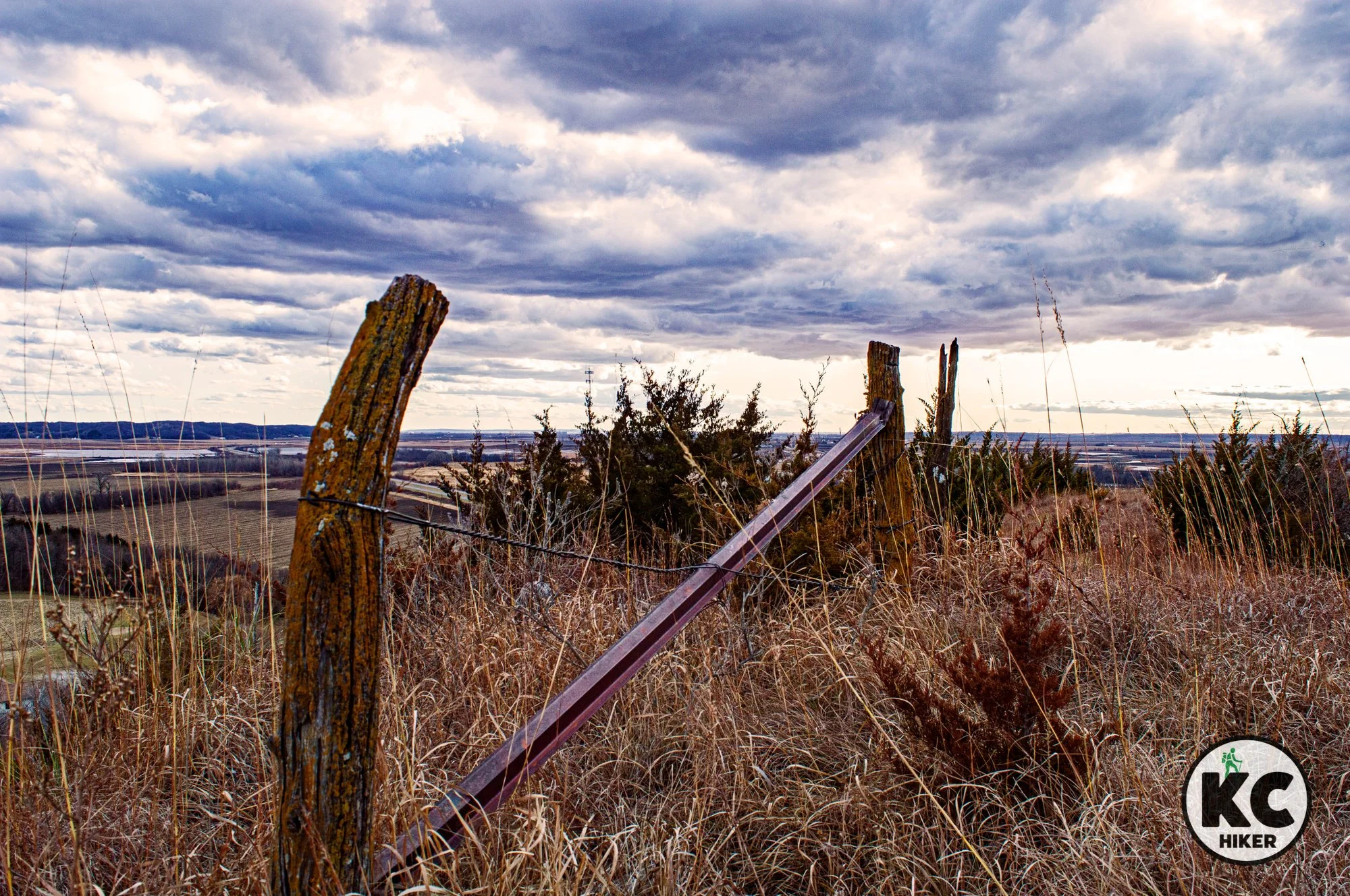
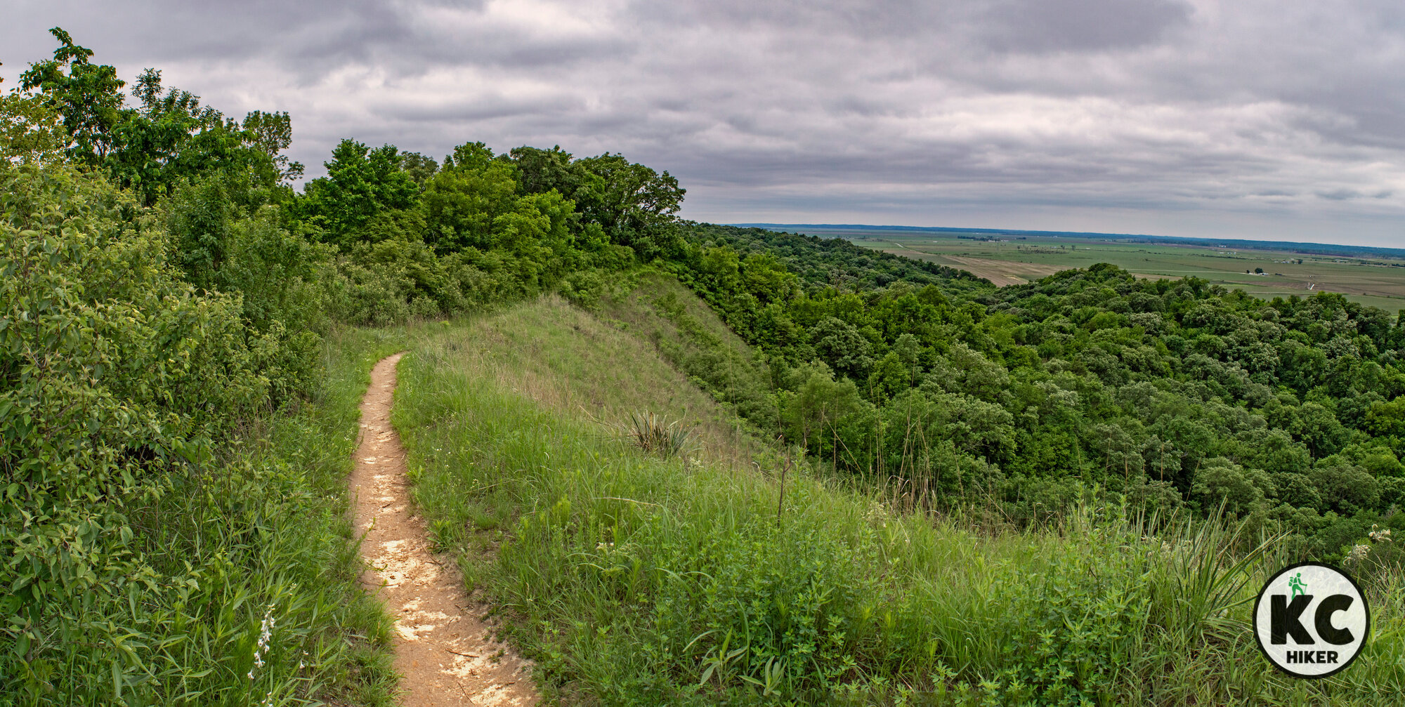
Explore the Kansas prairie at Wolf Creek
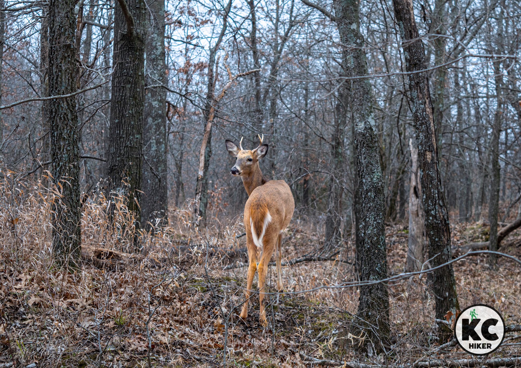
The 160-acre Wolf Creek Environmental Education Area gives visitors the opportunity to experience natural Kansas up close. It’s home to numerous varieties native wildlife and wildflowers. A highlight is the “silo” Eagle’s Nest wildlife viewing tower, which allows you to climb 65 stairs for a hawk’s view of the landscape.

This environmental education center includes a lookout tower and 3 miles of trails bordering Wolf Creek Reservoir.
Trail Wolf Creek Environmental Education Area
Overview
This remote prairie preserve gives visitors the opportunity to experience natural Kansas up close. It’s home to numerous varieties native wildlife and wildflowers. A highlight is the “silo” Eagle’s Nest wildlife viewing tower, which allows you to climb 65 stairs for a hawk’s view of the landscape. The 160-acre area is split into two sections. The silo is on the west side. The east side is accessed by a gated trailhead. If it’s locked, you can continue your journey on foot via the access road, then resume walking on the trails. Both areas contain bridges and boardwalks. Download our map to make the most of your experience.
If you want a more diverse experience, Wolf Creek Environmental Education Area is about 30 minutes from Eisenhower State Park. Visits to the two locations can easily be combined on the same day.
Drive Time It’s 90 minutes from Downtown Kansas City.
Length There are five trails, totaling about 3 miles in length.
Address and location
The eastern trailhead is on the north side of 17th Road NE at the intersection of Milo Lane. The west trailhead is a gated driveway that appears immediately after crossing the lake eastbound. The nearest landmark is the Eisenhower Training Center, which is a building owned by Evergy, the utility company. The Google map and trail map below may also be of assistance. The nearest community is New Strawn, Kan.Conditions This is a well-preserved trail that even has – wait for it – restrooms at the east trailhead. Trails are natural surface and are generally well-marked and maintained. There are few elevation changes.
Kid friendly? This is a natural surface trail, so children will need to walk or be carried.
How busy? This is remote area, so you are likely to have it to yourself unless there is a youth group visiting.
Pets Yes, on a leash, unless stated otherwise
Bikes Yes.


Eisenhower State Park straddles the Flint Hills and a miles of water
Nearly 30 miles of trails explore the rolling hills adjacent to Melvern Lake.

Eisenhower State Park, Kansas
Nearly 30 miles of trails explore the rolling hills adjacent to Melvern Lake.
Trail Eisenhower State Park trail system
Overview
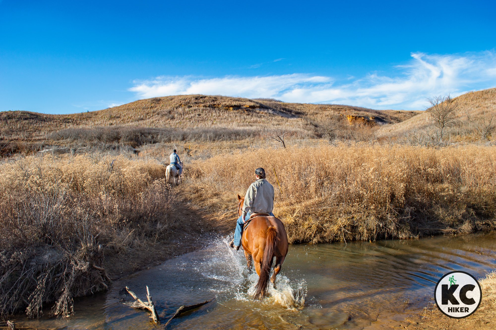
Only 90 minutes from Downtown Kansas City, Eisenhower State Park brings visitors into the prairies and Flint Hills of central Kansas. This is big sky country. The park is 1,700 acres in size and is divided between prairie and woodland. It borders the gargantuan Melvern Lake – nearly 7,000 acres large. Alongside Melvern is additional Corps of Engineers land to explore. A highlight of Eisenhower State Park is the 20-mile, wild and rambling horse trail network. There are other trails, too, but they’re closer to camping areas and traffic. The Flint Hills in this area aren’t quite as elevated as their cousins to the west and south, but they still deliver serenity and a feeling of splendid isolation. In addition to camping, the park offers cabins and even yurts for rent (scroll below for the state park website)
Drive Time It’s 90 minutes from Downtown Kansas City to the Eisenhower State Park office.
Length There are about 30 miles of trails of varying types in the park.
Address and location 29810 S. Fairlawn Road, Osage City, Kansas, 66523
Conditions The horse trail, which is the longest, is a natural surface trail. That means it’s muddy when wet. Pedestrian and bike trails are gravel surfaced. All trails, including the horse trail, are well-marked and maintained. Although it’s easy to follow, the horse trail’s sheer size (20 miles) makes it easy to get disoriented. A map or GPS tool is recommended.
Kid friendly? There are many opportunities for children to enjoy these trails. The horse trail will require everyone to walk. Other trails may be more crowded but are also more accessible.
How busy? Holidays, weekends and warm weather increase the population of this park. The area is large enough, however, that remote hikers will have plenty of peace. If you want a quieter experience, avoid peak days and seasons.
Pets Yes, on a leash.
Bikes Yes (and horses).


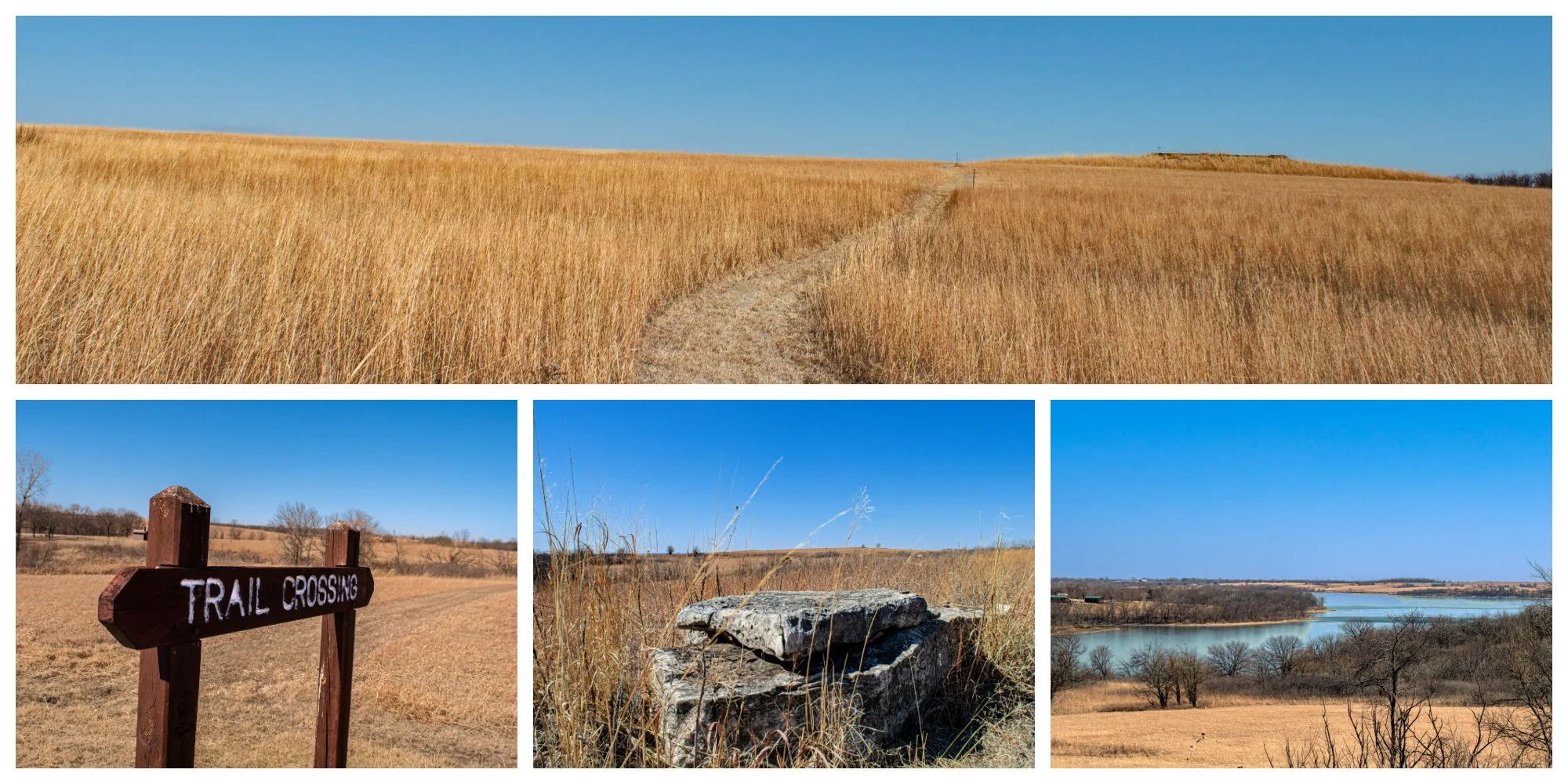
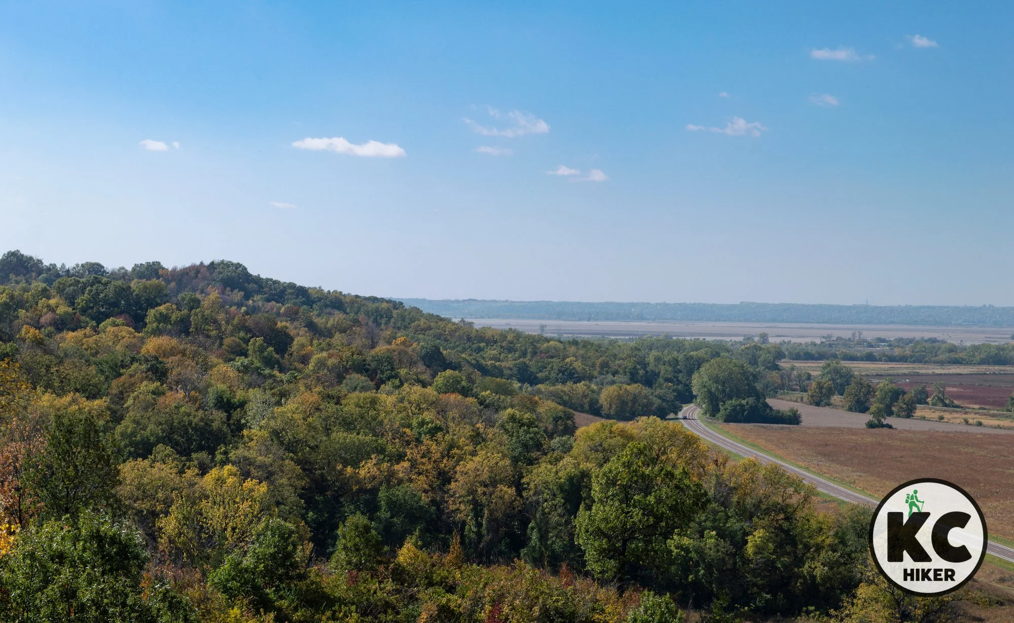
Flint Hills Trail: 100+ miles of pastoral delight
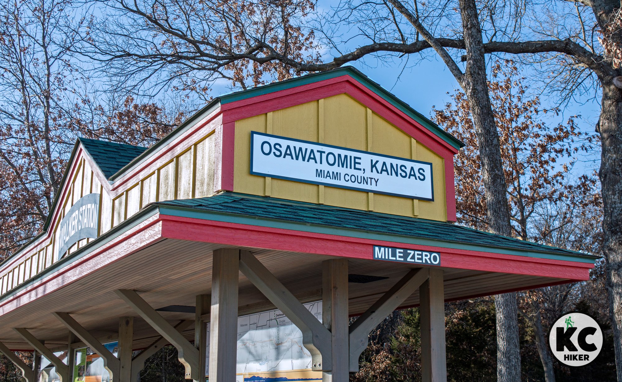
This 117-mile Flint Hills Trail is Kansas’ longest. In addition it’s the seventh-longest rail-trail in the United States. Mile zero is in Osawatomie. The trail stretches through rolling and pastoral scenery until it reaches Council Grove.

Flint Hills Trail, mile zero, Osawatomie, Kansas
Kansas’ longest trail stretches from Osawatomie to Council Grove.
Trail Flint Hills Trail
Overview
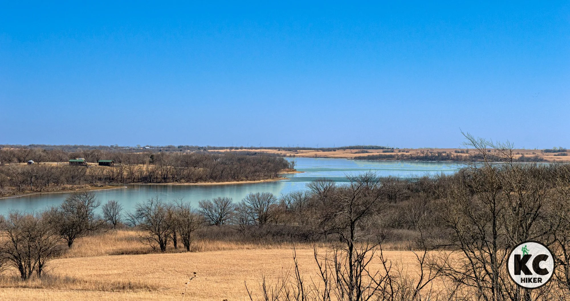
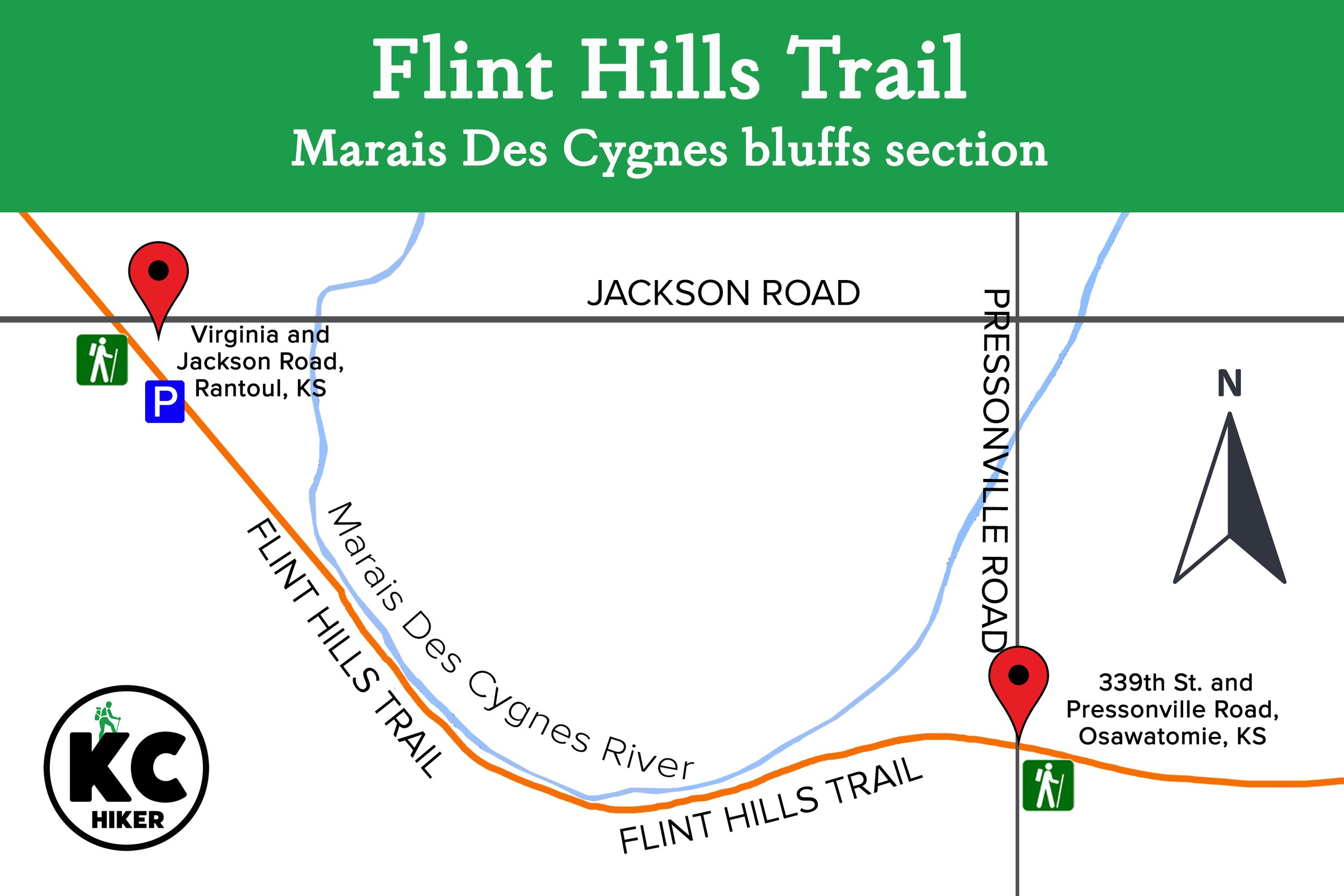
The Flint Hills Trail begins in Osawatomie, Kansas, in Miami County and will ultimately end in the small town of Herrington. It currently ends at the 92-mile marker in Council Grove. There’s plenty of serenity between Osawatomie and Council Grove, with the topography growing more rolling and scenic as you head west. This 118-mile rails-to-trail hiking and biking path was developed by the Kanza Conservancy. In addition to being Kansas’ longest trail, it is the seventh-longest rail-trail in the United States. One of its most-scenic sections runs along the Marais Des Cygnes River under towering, wooded bluffs (head west at the trailhead at 339th St. and Pressonville Road, Osawatomie as shown below).
The river, which runs near the trail for miles, is a beautiful natural fixture in and of itself. The trail’s environment ranges from lonely pastoral landscapes, to farmer’s backyards to wooded enclaves. The area is rich in both Native American and United States history and figured centrally in the Civil War. The “mile zero” trailhead in Osawatomie is about 10 miles from Ottawa, population 12,000. Ottawa is the largest city along the trail and provides ample services. If you’re biking, then riding to Ottawa, eating lunch and returning is a reasonable plan for the day. Bikes can also be rented in Ottawa.
The trail encounters increasingly hilly terrain as it progresses west. Highlights include scenic views west of the Bushong Trailhead and an offramp at the Kaw Nation Memorial.
The trail runs through communities including Rantoul, Ottawa, Pomona, Vassar, Osage City, Miller, Admire, Allen, Bushong, and Council Grove. It passes through five counties: Miami, Franklin, Osage, Lyon, and Morris.
Read more about different sections of the trail in our blog post on the Flint Hills Trail.
External links
Drive Time The easternmost trailhead, in Osawatomie, Kan., is 59 minutes from Downtown Kansas City. If you choose to start on the western side, in Council Grove, the drive is about two hours.
Length 118 miles
Address and location The trail can be accessed at 13 points from Osawatomie in the east to Herrington in the west. (Note: If you are planning to begin in Osawatomie and using Google Maps, it will take you to a residential address with no trail access. Instead, plug in the coordinates for Karl E. Cole Sports Complex, 900 12th St, Osawatomie, Kan., 66064. The trailhead is marked and can be found on the southwest side of the park. You can leave your vehicle right next to it.)
Conditions The trail is made of crushed gravel and is well marked and maintained. Elevation changes are minor. In wet weather, the trail is still passable and open, but will be soggy. The only “hazard” may be the occasional excited farm dog.
Kid friendly? This is a quiet, flat trail with no obstacles for children.
How busy? Much of this area is rural and remote so traffic is sparse. In populated areas traffic may be moderate.
Pets Yes, on a leash.
Bikes Yes (and horses).


Osawatomie, Kansas, Trailhead

Serenity rules at Marais des Cygnes refuge
A state and federal wildlife refuge provide 15,000 acres to hike, canoe, fish and photograph.
Marais des Cygnes National Wildlife Refuge
A state and federal wildlife refuge provide 15,000 acres to hike, canoe, fish and photograph.
Trail Marais des Cygnes National Wildlife Refuge and Marais des Cygnes (Kansas) Wildlife Area.
Overview
Marais des Cygnes (rhymes with “hooray machine!”) is the name of two adjacent wildlife refuges in eastern Kansas, about one hour from Downtown Kansas City. Both are open to the public and together comprise about 15,000 acres of wetlands, forest and hilly terrain. The centerpiece of the area is the Marais des Cygnes River. The name comes from both French and Osage names for the river, which translate to “where white swans are plentiful.” And the name says it all. The region is a major stopping point for migrating birds, including bald eagles and pelicans. Another resident of interest is the elusive flying squirrel.
The best word to describe the area rhymes with des Cygnes: serene. Bottomland hardwood forests cover much of the acreage, with the wide river cutting channels and leaving oxbow lakes behind it. The river is open to non-motorized boating. The state wildlife refuge is home to 200-foot hills that overlook the river near the village of Trading Post. In addition, reservoirs have been created to provide additional habitat.
Drive Time The area is about one hour from Downtown Kansas City.
Length There are about 6 miles of trails in the national wildlife refuge. The state refuge has no trails, but access is available through gravel service roads. Visitors are welcome to go off trail and explore, but be mindful of hunting seasons. See our trail map below for tips on where to hike.
Address and location Marais Des Cygnes National Wildlife Refuge, 16382 US-69, Pleasanton, KS 66075
Conditions Trails are well marked and generally consist of dirt roads and mowed pathways. See our map below for tips on the best areas to explore.
Kid friendly? This area would be a bumpy ride for strollers, so kids will need to be able to carry their own weight.
How busy? This is a remote area, but is popular with sportsmen, so time your visit to avoid major hunting season activity.
Pets Yes, on a leash.
Bikes No
Official websites


Coronado Heights: steeped in history and horizons
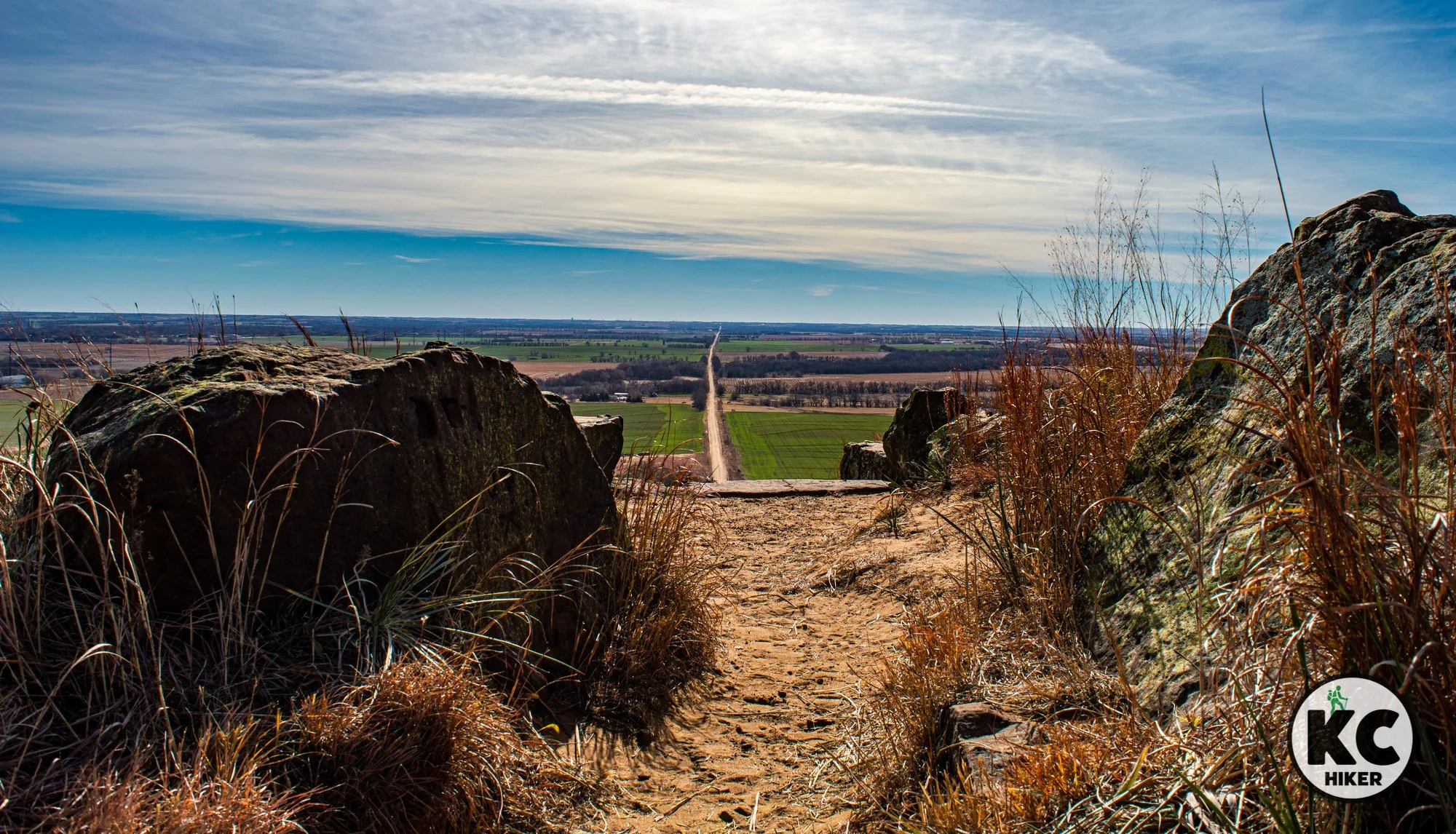
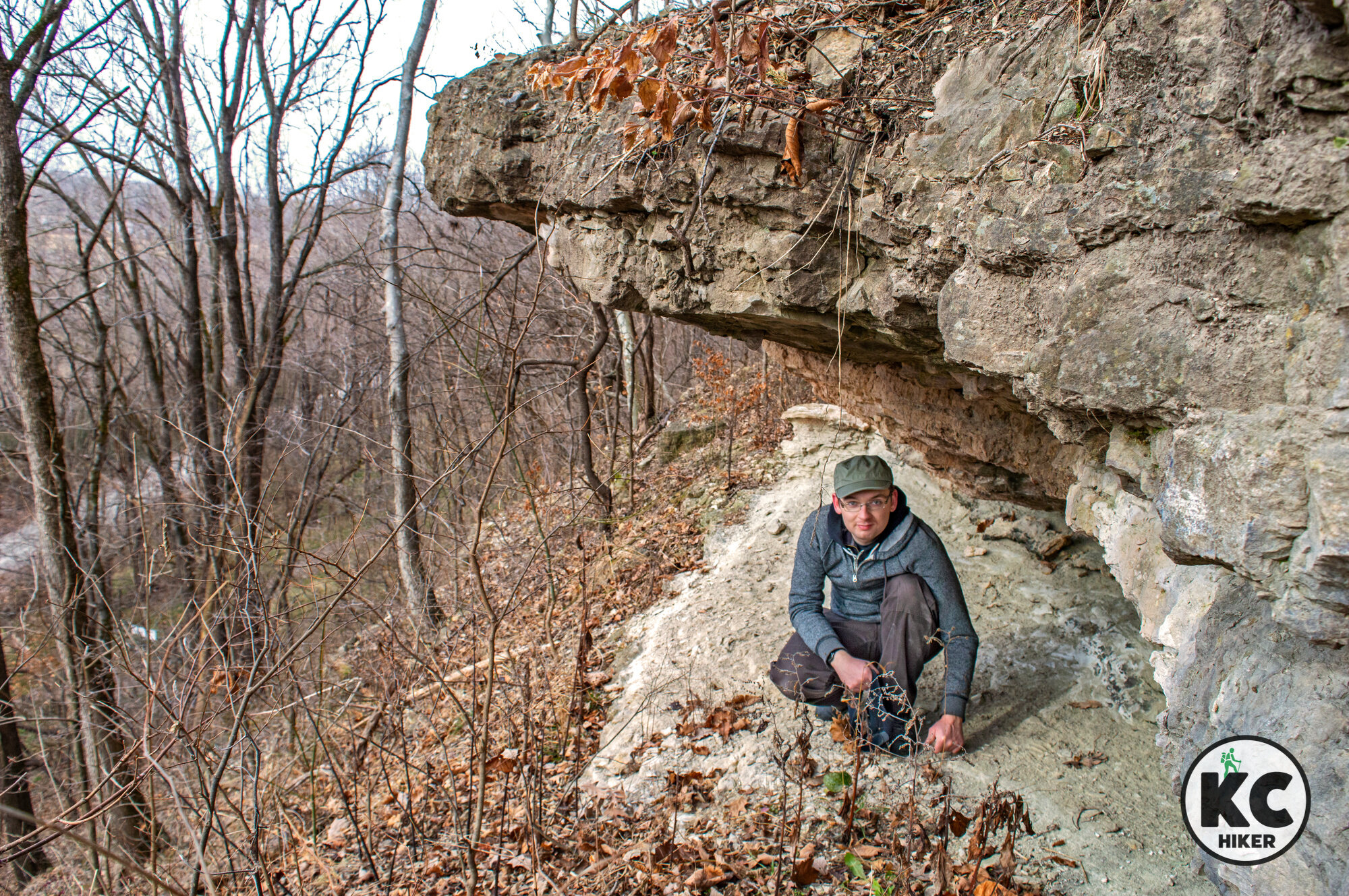
Coronado Heights sits atop a 300-foot-tall butte in Kansas’ Smoky Hills, near Lindsborg. Trails and a WPA-built picnic facility provide sweeping vistas of the prairie. The area is, at least to some degree, associated with Spanish explorer Coronado, who passed through the region in 1540. Searching for fabled cities of gold, he was surely disappointed in Kansas. Coronado went on to became the first European to see the Grand Canyon. Archeological finds, including chain mail, coins and explorers’ gear, tie Spaniards to the area.

Coronado Heights near Lindsborg, Kansas
It’s thought that Coronado, a conquistador, climbed this 300-foot butte around 1540. Regardless, you can scale it today.
Trail Coronado Heights trail system
Overview
Coronado Heights is a gem of backroads Kansas. And that’s part of its appeal. The 300-foot-tall butte rises above the plains near Lindsborg. On a clear day, you can see for miles. Several trail loops ring the cedar groves at the top of the hill and wind down around its base. If that were all, Coronado Heights would be worth visiting. But there’s legend as well. Spanish Conquistador Francisco Coronado came through the area in about 1540, searching for cities of gold. It’s theorized that he spent some time on Coronado Heights, surveying the area. Beyond legend, there’s hard evidence the Spaniards were here: Chain mail from their armor, coins and explorers’ gear have been found in the area.

Statue of a conquistador (not located at Coronado Heights).
Coronado did not build the monument at the top of the butte. It’s actually a picnic shelter built by another icon, President Franklin D. Roosevelt in 1936 (well not him, but his Works Progress Administration). Coronado went on to become the first European to see the Grand Canyon. But after finding no gold in Kansas, he threw up his hands and headed south to Mexico.
Coronado Heights is a must-see if you’re in central Kansas (Salina is the closest large town). It’s not a standalone destination however, more like a place to spend a half day. The good news is it’s close to several premiere Kansas hiking attractions: Kanopolis State Park and Mushroom Rock State Park. If you need a place to eat or want to shop, Lindsborg is a uniquely Swedish town famous for its artistic Dala horse creations.
Drive Time Coronado Heights is three hours from Downtown Kansas City.
Length There are about 2 miles of trails; if you wish to walk more you can backtrack some of the loops. There are also extensive hiking opportunities at Kanopolis State Park.
Address and location Coronado Heights Park, Smoky View, Kan., 67442.
Conditions The trails are natural surface and easy to find and follow, though they are largely unmarked. They are slippery after rain or snow. There are moderate elevation changes.
Kid friendly? Kids will need to be able to walk on their own.
How busy? On holidays and during warm weather, this trail gets moderate traffic. If you want a less-trafficked experience, visit on a weekday or in the offseason.
Pets Yes, on a leash.
Bikes Yes


Kanopolis State Park: Where the plains meet the Wild West
Kanopolis State Park, near Salina, Kan., is where the Wild West meets the plains. This park, when combined with the adjacent Smoky Hill Wildlife Area, consists of a sprawling 16,000 acres with 30 miles of trails. Set in the Smoky Hills, Kanopolis is marked by red sandstone outcroppings, overhangs and secluded canyons. Clear prairie streams trickle toward Kanopolis Lake.
Kanopolis State Park, near Salina, Kansas.
Explore canyons, rocky bluffs and pristine prairie in the shadow of great figures of the past.
Trail Kanopolis State Park Trail System
Overview
Kanopolis State Park, near Salina, Kan., is where the Wild West meets the plains. This park, when combined with the adjacent Smoky Hill Wildlife Area, consists of a sprawling 16,000 acres with 30 miles of trails. Set in the Smoky Hills, Kanopolis is marked by red sandstone outcroppings, overhangs and secluded canyons. Clear prairie streams trickle toward Kanopolis Lake. The place retains an aura of Western history: It was originally populated by Native American tribes of Pawnee, Cheyenne, Apache and Kiowa. They camped in these canyons and left petroglyphs describing their life hunting game. After them, famous personalities who passed through the area include George Custer, Buffalo Bill Cody and Wild Bill Hickok. Just the name Horse Thief Canyon, which trails run through, evokes the mystique and majesty of this place. Beyond the trails, the park’s attractions include Kanopolis Reservoir and a prairie dog colony.
Drive Time Via I-70, Kanopolis State Park is three hours and fifteen minutes from Downtown Kansas City.
Length There are 30 miles of trails in the park and nearby wildlife refuge.
Address and location Kanopolis State Park, 200 Horsethief Road, Marquette, Kan., 67464
Conditions Most trails are natural surface, but well marked and maintained. There are moderate elevation gains.
Kid friendly? Kids will need to be able to walk on their own.
How busy? On holidays and during warm weather, this trail gets moderate traffic. If you want a less-trafficked experience, visit on a weekday or in the offseason.
Pets Yes, on a leash.
Bikes Yes unless indicated otherwise.
Other area attractions
Mushroom Rock State Park, a small tract containing highly unusual, stunning rock formations, is nearby and is a must-see if you’re in the area.
Wilson Lake State Park is the home of miles of mountain bike and hiking trails. It’s home to sandstone cliffs, outcroppings and spires. It’s about one hour northwest of Kanopolis.
Coronado Heights is a butte in the Smoky Hills that may have been visited by the 16th century explorer. It includes a trail system that surrounds the butte.
Smoky Hill Wildlife Area
Because of its remoteness, Kanopolis is not a crowded park. However, if you really want to get away from it all, begin at the Smoky Hill Wildlife Area instead of the main park. The refuge borders the park to the west. You’ll experience the same type of terrain, but with fewer people. The main trail is a dirt road that leads into the park through the “back door” of Red Rock Canyon. There are several other trails in refuge, but it’s easy to get lost and they can be overgrown in summer. For the most reliable trail, begin at the Alum Creek Trail and Prairie Trail trailhead, which is mapped and pictured here. Then follow it as far as you want.


Mushroom Rock State Park is 10 miles from Kanopolis State Park in Kansas.

The Elk River Trail explores the Kansas you never knew
The Elk River Trail doesn’t seem like something you’d find in south central Kansas. Or, if you believe popular lore, anywhere in Kansas. But we’re richer because it does. This 15-mile trail is in the vicinity of Independence, Kansas, in Montgomery County. It begins at Elk City Lake and winds along clifftops, through ravines and forest and finally traverses the banks of the Elk River. There’s not a dull moment.

The 15-mile Elk River Trail, near Independence, Kansas.
Forested limestone cliffs and hills rise 200 feet above Elk City Lake, offering a 15-mile backpacking experience.
Trail Elk River Trail
Overview
The Elk River Trail doesn’t seem like something you’d find in south central Kansas. Or, if you believe popular lore, anywhere in Kansas. But we’re richer because it does. This 15-mile trail is in the vicinity of Independence, Kansas, in Montgomery County. It begins at Elk City Lake and winds along clifftops, through ravines and forest and finally traverses the banks of the Elk River. There’s not a dull moment.
The highlands, known as the Chautauqua Hills, rise up to 200 feet above the surrounding area. You can begin at the east trail head (on the lake) or the west trail head (near a bridge over the Elk River). There’s also a trailhead in the middle. Although the Elk River Trail is 15 miles long, you don’t have to hike the whole thing. Just pick a section and do an out-and-back. Through-hikers will be glad to know primitive camping is allowed anywhere along the trail, a privilege afforded by the U.S. Army Corps of Engineers, which owns the property. Campers seem to have done an excellent job of practicing “leave no trace,” with almost zero trash visible.
On the trail, you will be roughing it with very few “exit” ramps except a gravel road or two. Even then, you’ll have to walk for miles to get back to civilization. But you won’t want to leave. Cedar forests, rock outcroppings, boulders, a wide river and scenic lake beckon you forward. The Corps estimates the hike – each way – is 11 hours. From our personal experience, several more hours are needed. But why rush?
If you’re short on time, where should you start? Our recommendation is to hop on the east trail head, which immediately ascends into cliffs, boulders, woods and sheer joy.
Bonus
This trail can be combined with nearby Elk City State Park, which also provides challenging and scenic trails.
Length The Elk River Trail is 15 miles, each way. If you choose to explore nearby Elk City State Park, there are several more miles (and shorter trails) available.
Distance The drive to the east trailhead takes a little under three hours. The nearest town with services is Independence, Kansas. Accommodations are available in the area if you don’t want to camp in the woods.
Conditions This is a challenging trail. The surface is rock (much of it loose) and dirt. There are significant elevation gains and some minor rock climbing. It is well marked and maintained, so getting lost should not be an issue.
Kid friendly? Kids will need to be up for a strenuous hike.
How busy? On holidays and during warm weather, this trail gets plenty of traffic. If you want a less-trafficked experience, visit on a weekday or in the offseason.
Pets Yes, on a leash.
Bikes Yes unless indicated otherwise.
Official websites
Address and location The east, middle and west trail heads of the Elk River Trail are shown here. The east entrance is closest to the state park; the west entrance is adjacent to 160 Highway, just sough of Elk City.
EAST TRAILHEAD, ELK RIVER TRAIL
MIDWAY TRAILHEAD, ELK RIVER TRAIL
WEST TRAILHEAD, ELK RIVER TRAIL


View four states from Star School Hill Prairie
Star School Hill Prairie Conservation Area is a little known wildlife refuge in northwest Missouri, just short of the Iowa border. Yet it’s worth a visit, especially if you’re heading north on I-29. About 300 acres of rugged Loess Hills are open for exploration. Although the state map shows trails, they’re hard to find and follow, so it’s better to set out and explore on your own. The conservation area is bordered by I-29, so it’s easy to keep your bearings. These rugged hills launch steeply upward toward a wooded summit, about 250 feet above the Missouri River. Those who make it to the top can view Kansas, Nebraska, Iowa and, of course, Missouri. This is a special place that has maintained its wildness in spite of proximity to a major highway. The refuge is about two hours and fifteen minutes from Downtown Kansas City.
Star School Hill Prairie Conservation Area
This conservation area in northwest Missouri rises abruptly above the Missouri River Valley, offering spectacular views.
Trail Star School Hill Prairie Conservation Area
Overview
Star School Hill Prairie Conservation Area is a little known wildlife refuge in northwest Missouri, just short of the Iowa border. Yet it’s worth a visit, especially if you’re heading north on I-29. About 300 acres of rugged Loess Hills are open for exploration. Although the state map shows trails, they’re hard to find and follow, so it’s better to set out and explore on your own. The conservation area is bordered by I-29, so it’s easy to keep your bearings. These rugged hills launch steeply upward toward a wooded summit, about 250 feet above the Missouri River. Those who make it to the top can view Kansas, Nebraska, Iowa and, of course, Missouri. This is a special place that has maintained its wildness in spite of proximity to a major highway. The refuge is about two hours and fifteen minutes from Downtown Kansas City.
Star School Hill Prairie is best incorporated into a trip to the general vicinity. And that’s great, because there’s lots of hiking nearby. Options include:
Mt. Hope Cemetery, in Corning, Mo. This historic burial ground is managed through a partnership with the Missouri Department of Conservation. You’ll experience stunning views from the top of Mt. Hope. In this flood-prone region, cemeteries had to be placed on hilltops. The graveyard is rich with the history of German immigrants who farmed the area in the 1800s. Although there is no street address, here is a link to the location on Google Maps.

Mt. Hope Cemetery, in Corning, Mo., is managed through a partnership with the Missouri Department of Conservation.
Other nearby attractions include:
Arbor Day Farm is a family-oriented park (paid admission required) in Nebraska City, Neb. Lied Lodge, also in Nebraska City, is a unique, nature-oriented hotel.
Nebraska City is also home to the Lewis & Clark Interpretive Trail and Visitors Center (paid admission) and Arbor Lodge State Historical Park (paid admission).
About the Loess Hills
Loess hills were formed by wind-blown soil, not geologic uplift, glacial deposits or erosion. They’ve been described as having a “wrinkled” look. Their appearance is striking: Dirt-scarred hills shoot up suddenly from river bottom flatlands with no transition zone.These “crumbly” hills were devoid of trees in their natural state, often because wildfires and grazing buffalo and elk kept them bare. With fire suppression and farming came trees, so much of the hill range is cloaked in forest. Yet much of the original “fire” remains in these hills, with plants usually associated with the West popping up here.
While loess soils are not unique to Missouri and Iowa, their size here is unmatched except for a region in China. This region is truly unique in the Americas.
Length Although the state map indicates trails, they are difficult to find. It’s better to plan on wandering. You can explore for a couple of hours (or until you’re out of breath from the elevation gains). The western border is I-29, so it’s easy to keep your bearings.
Address and location There is no street address and no direct access from I-29. Therefore, you must access the area from Rockport, Mo., or Hamburg, Iowa. The Google Maps location is linked here. Also note that this refuge is split into two sections: one on the north and one on the south. Both are worth exploring (see the map for details).
Conditions There are no trails and this is rough ground to traverse. Plan on getting a good workout and wear sturdy footwear.
Kid friendly? Kids will need to be up for a strenuous hike and no trail.
How busy? This area is lightly trafficked. Note that hunting is allowed here during official state of Missouri seasons.
Pets Yes, on a leash.
Bikes Yes unless indicated otherwise.


View eagles from rugged hilltops at Loess Bluffs NWR
Loess Bluffs National Wildlife Refuge sprawls across more than 7,000 acres, north of St. Joseph, Mo. It’s best known as a place to see eagles and other migrating waterfowl. And it certainly is. Lesser known are its more than 4 miles of trails that explore the rugged Loess Hills.

Loess Bluffs National Wildlife Refuge, Forest City, Mo.
This national wildlife refuge is best known for wildlife viewing. Lesser known are its rugged trails leading to epic summit views.
Trail Loess Hills National Wildlife Refuge
Overview
Loess Bluffs National Wildlife Refuge sprawls across more than 7,000 acres, north of St. Joseph, Mo. It’s best known as a place to see eagles and other migrating waterfowl. And it certainly is. Lesser known are its more than 4 miles of trails that explore the rugged Loess Hills. Four miles may not sound like much mileage, but walking these hills will exhaust you (though it’s certainly worth it). Epic summit views allow hikers to take in a panoramic landscape of prairie, lakes and wildlife. The Audubon Society has designated it a Globally Important Bird Area. The refuge is less than two hours from Downtown Kansas City.
If you’re headed to see birds, the refuge has a waterfowl counter on its website. You can also call to get the latest on migrations and population: 660.442.3187. Note: Many will want to view waterfowl on the refuge’s north side via the auto tour. Be forewarned that this 10-mile tour is one-way on a gravel road. Once you begin, you’re committed.
About the Loess Hills
Loess hills were formed by wind-blown soil, not geologic uplift, glacial deposits or erosion. They’ve been described as having a “wrinkled” look. Their appearance is striking: Dirt-scarred hills shoot up suddenly from river bottom flatlands with no transition zone.
These “crumbly” hills were devoid of trees in their natural state, often because wildfires and grazing buffalo and elk kept them bare. With fire suppression and farming came trees, so much of the hill range is cloaked in forest. Yet much of the original “fire” remains in these hills, with plants usually associated with the West popping up here.
While loess soils are not unique to Missouri and Iowa, their size here is unmatched except for a region in China. This region is truly unique in the Americas.
Bonus
Nearby attractions include:Arbor Day Farm is a family-oriented park (paid admission required) in Nebraska City, Neb. Lied Lodge, also in Nebraska City, is a unique, nature-oriented hotel.
Nebraska City is also home to the Lewis & Clark Interpretive Trail and Visitors Center (paid admission) and Arbor Lodge State Historical Park (paid admission).
Length There are 4 miles of trails with a dirt surface. The auto tour is 10 miles on a one-way gravel road.
Address and location Loess Bluffs National Wildlife Refuge,
25542 US-159, Forest City, Mo., 64451. The drive takes less than two hours from Downtown Kansas City.Conditions Trails are packed dirt and well marked and maintained. Steep elevation gains can make the hiking challenging.
Kid friendly? This trail is for children who can carry their own weight. There are some sheer drop-offs, so parents will need to keep their eyes on smaller children.
How busy? This area is moderately trafficked. If you are seeking a quieter experience, visit on a weekday or in the offseason.
Pets Yes, on a leash.
Bikes Yes unless indicated otherwise.


Explore river bluff backcountry at Hitchcock Nature Center
Western Iowa’s Hitchcock Nature Center is one of the best opportunities to explore the range known as the Loess Hills. Here, ridges rise 300 feet above the Missouri River bottomlands, providing picturesque sunsets. The park’s visitors center has a 45-foot tall hawk watching tower, allowing you to watch raptors and other birds navigating the wind currents. Ten miles of trails explore this 1,268-acre park.

Hitchcock Nature Center, Honey Creek, Iowa
Hike 10 miles of trails on more than 1,000 acres of Loess Hills forest and prairie near Omaha.
Trail Hitchcock Nature Center trail system
Overview
Hitchcock Nature Center is a 1,268-acre preserve of the Pottawattamie County, Iowa, park system. Although the Loess Hills run from north of St. Joseph, Mo., to South Dakota, most of this scenic ridgeline is on private property. That leaves plenty of stunning vistas, but few places to actually experience nature up close. Hitchcock Nature Center is one of the best opportunities to explore these unusual hills. Here, Loess ridges rise 300 feet above the Missouri River bottomlands, providing picturesque sunrises and sunsets. On clear days, the skyline of Omaha, Neb., is visible in the distance. The park’s visitors center has a 45-foot tall hawk watching tower, allowing you to view raptors and other birds navigating the wind currents. Capitalizing on the steep grade is the nearby Mt. Crescent Ski Area. Hitchcock is opened year round and rents snowshoes in winter months. Several backcountry, primitive camping sites are available, along with a few cabins. It’s a three hour drive from Downtown Kansas City.
About the Loess Hills
Loess hills were formed by wind-blown soil and not by geologic uplift, glacial deposits or erosion. They’ve been described as having a “wrinkled” look. Their appearance is striking: Dirt-scarred hills shoot up suddenly from river bottom flatlands with no transition zone. Natural terraces often form.
These “crumbly” hills were devoid of trees in their natural state, often because wildfires and grazing buffalo and elk kept them bare. With fire suppression and farming came trees, so much of the hill range is cloaked in forest. Yet much of the original “fire” remains in these hills, with plants usually associated with the West (such as Yucca) popping up here.
While loess soils are not unique to Missouri and Iowa, their size here is unmatched except for a region in China. This region is truly unique in the Americas.
Bonus
Nearby attractions include:
Arbor Day Farm is a family-oriented park (paid admission required) in Nebraska City, Neb. Lied Lodge, also in Nebraska City, is a unique, nature-oriented hotel.
Nebraska City is also home to the Lewis & Clark Interpretive Trail and Visitors Center (paid admission) and Arbor Lodge State Historical Park (paid admission).
Length There are 10 miles of trails that wind through all corners of the park. They are well marked, dirt paths. Since the hills are prone to steep, sudden elevation gains, some of the hiking is challenging.
Address and location Hitchcock Nature Center, 27792 Ski Hill Loop, Honey Creek, Iowa, 51542
Conditions Trails are packed dirt and well marked and maintained. Steep elevation gains can make the hiking challenging. There is no water available outside the visitors center, so bring plenty on hot days.
Kid friendly? Most of these trails is for children who can carry their own weight. Strollers won’t budge. There is a short gravel educational loop near the visitors center for kids who are up for a shorter adventure.
How busy? This area is near Omaha, Neb., and Council Bluffs, Iowa, and is moderately trafficked. If you are seeking a quieter experience, visit on a weekday or in the offseason.
Pets Yes, on a leash.
Bikes Yes unless indicated otherwise.
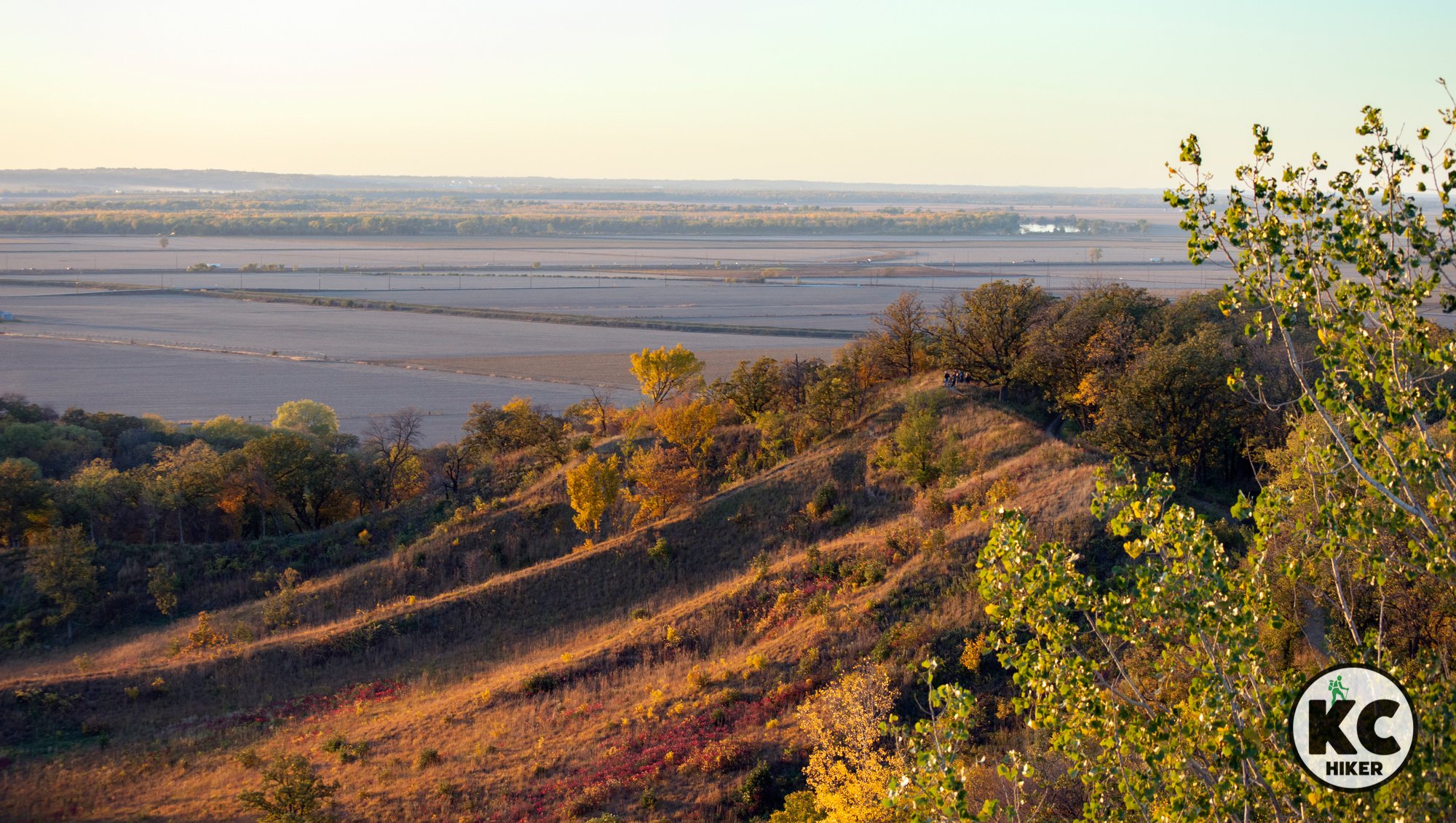


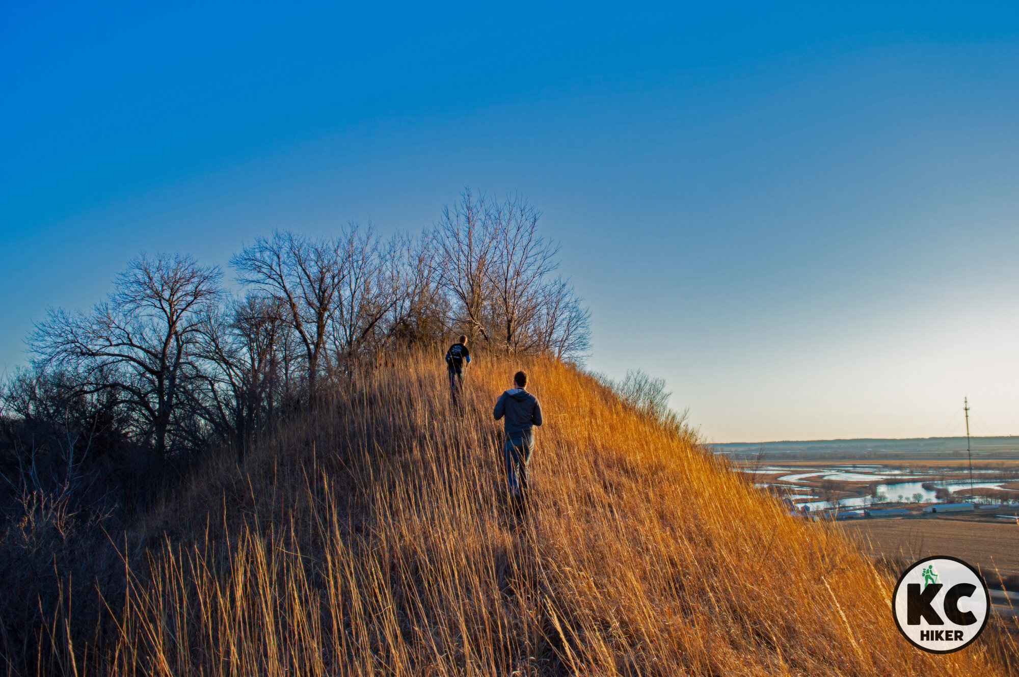
Ghosts of the past echo at Mt. Mitchell Heritage Prairie
Mt. Mitchell is the epitome of stark Flint Hills beauty. About 170 acres of tallgrass prairie rise 250 feet above the Kansas River and lowland plains, giving a glimpse of what the prairie used to be. More than 2 miles of trails wind around the summit, head-tall grass and historical markers of this isolated location.

Mt. Mitchell Heritage Prairie, near Manhattan and Wamego, Kan.
Native Americans, mountain men and Underground Railroaders are in the DNA of this scenic Flint Hills preserve.
Trail Mt. Mitchell Heritage Prairie
Overview
Mt. Mitchell is the epitome of stark Flint Hills beauty. About 170 acres of tallgrass prairie rise 250 feet above the Kansas River and lowland plains, giving a glimpse of what the prairie used to be. More than 2 miles of trails wind around the summit, head-tall grass and historical markers of this isolated location. Views soar into eternity as clouds roll by. At Mt. Mitchell, you’re stepping in the footprints of giants: Native Americans, explorers, mountain men and heroes of the Underground Railroad. This preserve of nature and history, about two hours from Kansas City, is a must-see for fans of the Flint Hills.Bonus
A nearby, similar, attraction is Konza Prairie Biological Station, which is about 45 minutes west. The topography is similar except the Konza Prairie is a much larger area with more miles of trails. Mt. Mitchell Heritage Prairie is also about 30 minutes from Pillsbury Crossing, a wildlife area centered around a Flint Hills Waterfall. Food and restrooms can be found nearby in Wamego or Manhattan, Kan.
Length There are 2.5 miles of gravel and mowed paths.
Address and location Mt. Mitchell Heritage Park, 29377 Mitchell Prairie Ln, Wamego, Kan., 66547.
Conditions Trails are gravel and mowed paths. No matter which path you take, you’ll experience at least 100 feet of elevation gain. However, the hills are of moderate difficulty and require no advanced skills. Trails are well marked and benches are placed along the path, as are some historical/nature displays.
Kid friendly? These trails aren’t stroller-friendly, so children will need to walk or be carried. There is plenty of room to roam and for kids to wander and play. Although hills are steep, there are no sheer drops.
How busy? This is a remote area, so you’ll be hard pressed to find a time when it’s too populated.
Pets Yes, unless posted otherwise.
Bikes Yes, unless posted otherwise.


Reach for the Sky at Tallgrass Prairie National Preserve
Tallgrass Prairie National Preserve holds some of North America’s last undisturbed tallgrass prairie. Its 11,000 acres, near Cottonwood Falls, Kansas, include 40 miles of trails. Epic rolling hills appear to recede into eternity. A herd of bison roam the preserve, which is also home to prairie birds and waterfowl. The park includes an educational visitors’ center as well as a preserved late 1800s-era ranch including a home, barn and other structures.

Tallgrass Prairie National Preserve, Strong City, Kan.
Thousands of acres of pristine prairie beckon to be explored.
Trail Tallgrass Prairie National Preserve
Overview
This national park holds some of the last undisturbed native tallgrass prairie. Its 11,000 acres include 40 miles of trails. Epic rolling hills appear to recede into eternity. In addition to Flint Hills wildlife such as white-tailed deer, bobcats, coyotes and beaver, a herd of bison roam the preserve. The park includes an educational visitors’ center as well as a preserved late 1800s-era ranch including a home, barn and other structures. A stone, one-room schoolhouse built in 1889 has becoming an iconic symbol of the prairie. In addition to the backcountry trails, a shorter nature trail begins near the visitors’ center. The preserve features upland trails that explore thousands of acres of ranch country. But there is also an extensive bottomland area and stream that is just as worthy of hiking.
Length There are 40 miles of trails, ranging from nature paths to long hikes in the backcountry.
Address and location Tallgrass Prairie National Preserve, 2480B KS-177, Strong City, Kan., 66869.
Conditions Trails are old gravel ranch roads and mowed paths. They are well marked and maintained. Depending on where you hike, elevation gain can be extensive. The National Park Service says this about disability access: “The Bottomland Trail is wheelchair friendly (except when wet) with trailhead kiosk, five interpretive waysides, wheelchair accessible comfort station, picnic area, benches, and two varying length trails of 3/4 or 1/2 mile. Handicap parking (gravel, but close to the trailhead) is available.”
Kid friendly? These trails aren’t stroller-friendly, so children will need to walk or be carried. There is plenty of room to roam and for kids to wander and play. Of course, keep an eye on your kids (and yourself) in the presence of bison. They roam freely. The visitor’s center is an excellent stop for kids, with exhibits they can see and touch.
How busy? This is a remote area, so you’ll be hard pressed to find a time when it’s too populated.
Pets Prohibited, except on the Southwind Nature Trail.
Bikes Prohibited.


Soar above the Missouri River at Indian Cave State Park
Indian Cave State Park’s namesake is a rocky overhang (not really a cave) that contains Native American prehistoric petroglyphs. While this is interesting, the real treasure for nature lovers and hikers is its rugged terrain and spectacular bluff-top views. Indian Cave State Park consists of more than 3,000 acres of mostly forested, steep hills that shoot up nearly vertically from the Missouri River. It’s part of a Missouri River valley region known as the Loess Hills. More than 20 miles of trails traverse this unique area. Primitive campsites are also available. Indian Cave is a unique hiking location for the Farm Belt.

Indian Cave State Park, Nebraska
Loess Bluffs rise 300 feet above the river below, while forests and prairie are rich with beauty and wildlife.
Trail Indian Cave State Park trail system
Overview
Indian Cave’s namesake is a rocky overhang (not really a cave) that contains Native American prehistoric petroglyphs. However, in our opinion, the cave is merely a pleasant diversion. The real treasure of this park is its rugged terrain and spectacular bluff-top views. Indian Cave State Park consists of more than 3,000 acres of mostly forested, steep hills that shoot up nearly vertically from the Missouri River. It’s part of a Missouri River valley region known as the Loess Hills.
Loess refers to wind-blown soil. That means these “crumbly” hills are different than others caused by geologic uplift, glacial deposits or erosion. Unlike the Flint Hills of Kansas, there are few rocks to be found in this porous soil. These hills were mostly devoid of trees in their natural state, but with fire suppression and farming came trees, so much of the hills are cloaked in forest.
Hikers have 22 miles of challenging dirt trails in which to explore the hills, forests and plains of the park. There is also a large riverfront marsh area that is a prime viewing area for waterfowl. You can sit on a bank and watch the river go by.
In addition, this park is unique in the plains region of the Midwest in that it offers primitive, backcountry camping. City slickers can have a real-life backpacking adventure here if they want one. You can pitch a tent around a campfire or use one of several Adirondack shelters. You don’t have to “bear bag” your food, as you would in the Appalachians, Mountain West or even the Ozarks. Surprise! There are no bears in Nebraska. Indian Cave State Park a little more than two hours’ drive from Downtown Kansas City.
For history buffs, the restored remains of the ghost town of St. Deroin can also be explored in the park.
Bonus
Nearby hiking and natural attractions include:
Arbor Day Farm is a family-oriented park (paid admission required) in Nebraska City, Neb. Lied Lodge, also in Nebraska City, is a unique, nature-oriented hotel.
Nebraska City is also home to the Lewis & Clark Interpretive Trail and Visitors Center (paid admission) and Arbor Lodge State Historical Park (paid admission).
Length There are 22 miles of challenging trails. These are natural surface (dirt) and some are akin to mountain climbing, with steep grades going up nearly 300 feet on a single hill. Of course you don’t have to take the most challenging trails, but if you want the view from the top, there’s no other way.
Address and location Indian Cave State Park, 65296 720 Rd , Shubert, Neb., 68437-9801. The park is about two hours and fifteen minutes from Downtown Kansas City.
Conditions There are some extremely challenging trails amid the 22 miles, but hikers can also find more leveled paths. Trails are well marked and maintained but are natural surface (dirt). There is a level, riverfront area that is accessible to people with disabilities. Most of the trails are suited for walkers who are in reasonable physical health.
Kid friendly? These trails can be challenging for children. Scaling steep inclines can be exhausting. In addition, parents need to be mindful of steep and sometimes sheer vertical drops from the cliffs.
How busy? This area is moderately trafficked and busy on holiday weekends. If you are seeking a quieter experience, visit on a weekday or in the offseason.
Pets Yes, on a leash.
Bikes Yes, except where posted otherise.


Walk the wild Loess Hills at Waubonsie State Park
Iowa’s Waubonsie State Park offers endless vistas atop ridges of the Loess Hills. Missed by the masses, these unique hills of western Iowa offer a mystical experience to those who find them. Nine miles of trails explore deep woods, ravines and ridgetops. Wildlife and wildflowers are abundant.
Waubonsie State Park, near Hamburg, Iowa
Missed by the masses, these unique hills of western Iowa offer a mystical experience to those who find them.
Trail Waubonsie State Park trail system
Overview
Iowa’s Waubonsie State Park is within sight of I-29, but most motorists rush down the highway unaware of this spectacular enclave of nature. Waubonsie – and most of extreme western Iowa – is defined by the Loess Hills. It’s a band of terrain up to 15 miles wide and span 200 miles from St. Joseph, Mo., to South Dakota.Loess refers to wind-blown soil. That means these hills look different than others caused by geologic uplift, glacial deposits or erosion. They’ve been described as having a “wrinkled” look. Their appearance is striking: Dirt-scarred hills shoot up suddenly from river bottom flatlands with no transition zone. Some rise up to 300 feet above the Missouri River bottomlands.
These “crumbly” hills were devoid of trees in their natural state, often because wildfires and grazing buffalo and elk kept them bare. With fire suppression and farming came trees, so much of the hill range is cloaked in forest. Yet much of the original “fire” remains in these hills, with plants usually associated with the West popping up here.
While loess soils are not unique to Missouri and Iowa, their size here is unmatched except for a region in China. This region is truly unique in the Americas.
Waubonsie State Park is a prime example of this unique geological phenomenon. You’ll find plunging hillsides, dark forest, endless vistas, wildflowers and wildlife.
Bonus
On the way to Waubonsie, motorists will pass:Indian Cave State Park (Shubert, Neb.).
All are excellent places to explore the Loess Hills. If you are looking for food or lodging near Waubonsie, you can find it in Hamburg, Iowa, or Nebraska City, Neb. Both are about 15 minutes from the park.
Arbor Day Farm is a family-oriented park (paid admission required) in Nebraska City, Neb. Lied Lodge, also in Nebraska City, is a unique, nature-oriented hotel.
Nebraska City is also home to the Lewis & Clark Interpretive Trail and Visitors Center (paid admission) and Arbor Lodge State Historical Park (paid admission).
Length There are 9 miles of trails, with 5 of those on an equestrian trail on the north side of the park. Although the 5-mile equestrian trail is the longest, it’s not a scenic as the trails in the main park unit. The 2-miles Sunset Ridge Trail is highly recommended, although all of them provide prime opportunities to explore this unique environment. If you are an experienced hiker, you can walk most of the park’s non-equestrian trails in about two hours.
Address and location Waubonsie State Park, 2585 Waubonsie Park Road, Hamburg, Iowa, 51640
Conditions Trails are either crushed rock or dirt. They are well marked. By the nature of this being a park in the midst of hills, there are challenging elevation changes. If you simply want to view the scenery, you can easily park and walk the short Overlook Trail without breaking a sweat.
Kid friendly? This trail is for children who can carry their own weight.
How busy? This area is moderately trafficked. If you are seeking a quieter experience, visit on a weekday or in the offseason.
Pets Yes, on a leash.
Bikes Check with the park because bikes are prohibited on some trails.


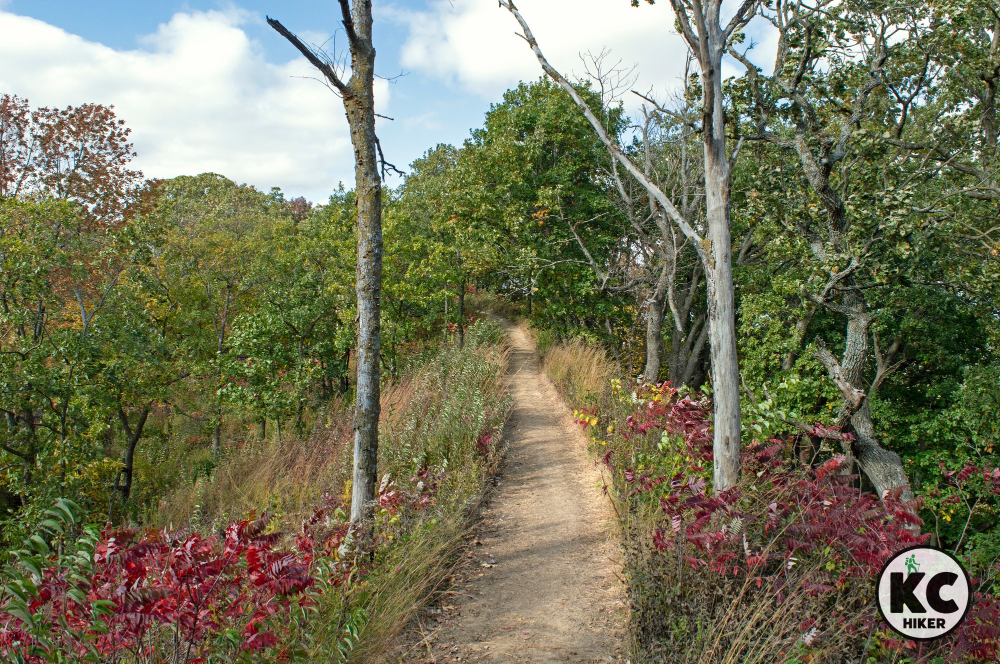
Konza Prairie: An island of pristine Flint Hills wildland
The 6,800-acre Konza Prairie Biological Station demonstrates what the Flint Hills and Kansas prairie looked like 250 years ago. The preserve is vast, rolling, rocky and awesome. It’s a must-see for anyone interested in hiking Kansas or even the Midwest. Konza is a combination of wind-blasted ridges, rocky valleys and forested groves and bottomland.

Konza Prairie near Manhattan, Kan.
Kansas State University and the Nature Conservancy have preserved nearly 8,000 acres of natural prairie.
Trail Konza Prairie Biological Station
Overview
The 7,700-acre Konza Prairie Biological Station demonstrates what the Flint Hills and Kansas prairie looked like 250 years ago. The preserve is vast, rolling, rocky and awesome. It’s a must-see for anyone interested in hiking Kansas or even the Midwest. Konza is a combination of wind-blasted ridges, rocky valleys and forested groves and bottomland. Far from being a desert, the reserve is intersected by crystalline streams, ancient boulders and spectacular wildflowers. Wildlife is also abundant, including numerous bird species, lizards, deer, bobcats, coyotes and prairie chicken (among others).
Length There are about eight total miles of trails in the preserve. The trail system consists of three loops. The 6-mile Godwin Hill loop is the longest, but a series of exits allow you to walk a shorter two- or four-mile trip.
Address and location Konza Prairie Biological Research Station, 100 Konza Prairie Ln, Manhattan, Kan., 66502
Conditions These trails are natural surfaces consisting of natural rock, crushed rock or mowed pathways. They are well maintained and easy to follow. Elevation changes will challenge hikers, with many ups and downs. The Konza hills rise between 300-400 feet above the surrounding Kansas River plain.
Kid friendly? This trail is for children who can carry their own weight, don’t mind walking for a couple of hours and enjoy nature. Bikes are not allowed and strollers would be impossible to maneuver.
How busy? On pristine days, this area can be busy given its proximity to Manhattan, Kan. However, on weekdays and in the offseason, you may be nearly alone in the park. The most distant loop is the least traveled.
Pets Prohibited.
Bikes Prohibited.
Other area destinations
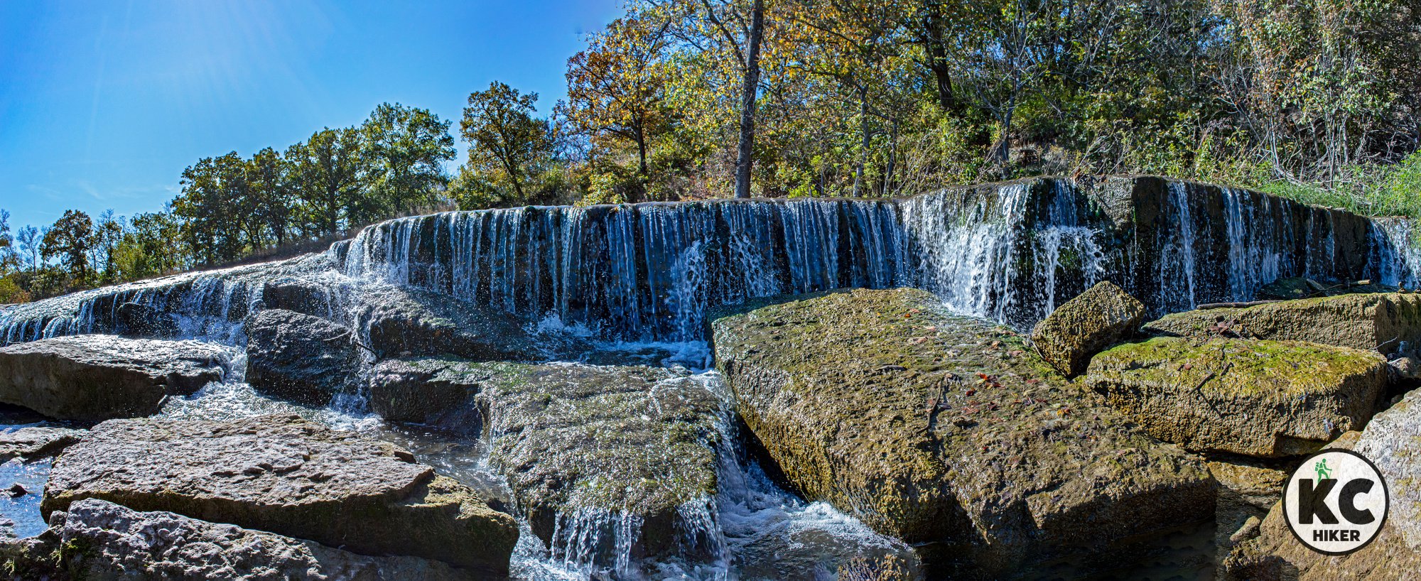
The Konza area is near Pillsbury Falls, contained within the Pillsbury Crossing Wildlife Area. The falls are 5-feet high and 40-feet wide. Visitors will have to ford a (usually) shallow stream to get a close view of the falls. This can be done on foot or in a vehicle.
In addition, Manhattan, Kan., is a unique college town with distinctive shopping and dining in the Aggieville District.


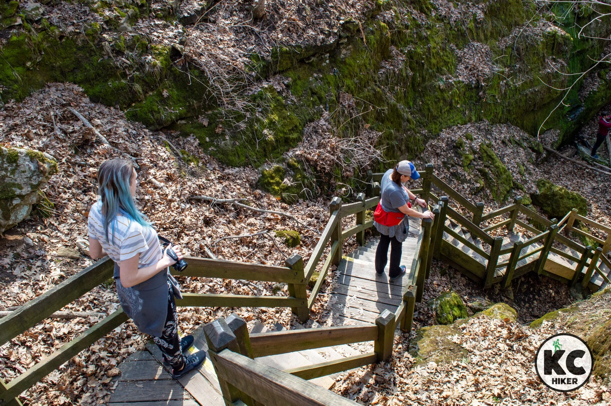
Water sculpts stone at Rock Bridge Memorial State Park
Rock Bridge Memorial State Park sprawls across more than 2,000 acres near Columbia, Mo. The focal point of the park is the rock bridge. It’s really not a bridge, per se, but the opening of a giant collapsed cave. The “bridge” is all that remains. A clear stream runs under the natural bridge after emerging from limestone bluffs. There are other unique geological features at the park, including the Devil’s Icebox. The name is derived from the cooler temperatures in the cave, which can be accessed via a wooden stairwell. While those features are highlights, they can be enjoyed in less than an hour and are only five minutes from the parking lot. If you’re in for the day, the park has more than 27 miles of trails, including Gans Creek Wild Area, a remote part of the park that can be explored via a 6.6-mile loop.

Rock Bridge Memorial State Park, near Columbia, Mo.
The natural bridge is the main draw to this park, but it’s far from the only feature. Explore cliffs, woods and caves on 27 miles of trails.
Trail Rock Bridge Memorial State Park, including Gans Creek Wild Area
Overview
Rock Bridge Memorial State Park sprawls across more than 2,000 acres near Columbia, Mo. The focal point of the park is the rock bridge. It’s really not a bridge, per se, but the opening of a giant collapsed cave. The “bridge” is all that remains. A clear stream runs under the natural bridge after emerging from limestone bluffs. There are other unique geological features at the park, including the Devil’s Icebox. The name is derived from the cooler temperatures in the cave, which can be accessed via a wooden stairwell. While those features are highlights, they can be enjoyed in less than an hour and are only five minutes from the parking lot. If you’re in for the day, the park has more than 27 miles of trails, including Gans Creek Wild Area, a remote part of the park that can be explored via a 6.6-mile loop.
Length There are more than 27 miles of trails in Rock Bridge Memorial State Park. A trail overview and map for Gans Creek Wild Area are included below. You can download individual maps for all trails on the state park website.
Address and location 5901 S. Highway 163, Columbia, Mo., 65203-8195.
Conditions These are natural surface trails, ranging from dirt to pea gravel. There are also wooden walkways to ease access and to protect the fragile environment of some areas. There is a diversity of topography given that there are 27 miles of trails in the park. They range from steep uphill climbs to lazy walks through the prairie.
Kid friendly? There is much for children to explore here, but parents need to be mindful of steep drops. If they explore the natural bridge area, water safety should be practiced.
How busy? The main bridge area is highly trafficked. However, many outlying trails are moderately trafficked or have few hikers. The Gans Creek Wild Area, at 600 acres, is popular but allows walkers to spread out among the woods and cliffs.
Pets Yes, on a leash (unless otherwise designated).
Bikes Yes, unless otherwise noted.
Official website Rock Bridge Memorial State Park
Other hiking opportunities near Columbia, Mo.


Towering cliffs and serenity: KATY Trail at Hart Creek Conservation Area
Hart Conservation Area, along the KATY Trail in Boone County, Mo., is scenic and rugged hike that you’ll likely have to yourself. Beginning at the small, riverside town of Hartsburg, you can walk a loop down the KATY, rise into the hills at the conservation area, then return to the village.
Hart Conservation Area and the KATY Trail, Hartsburg, Mo., Boone County
A ridgetop trail traverses mid-Missouri timber before intersecting with the KATY Trail.
Trail Hart Creek Conservation Trail and the KATY Trail.
Overview
Hart Creek Conservation Area, between Jefferson City and Columbia, Mo., includes about 650 acres of upland timber, ridges and Missouri River bluffs. A natural surface trail that’s about 1.5 miles long begins at the conservation area parking lot near the small town of Hartsburg, Mo. It leads up a ridge, through forest and provides a detour to an overlook of the Missouri River Valley. The trail continues downward and connects with the KATY Trail. The KATY Trail runs along the base of spectacular river bluffs that are part of the conservation area. Follow the KATY south and you’ll enter the town of Hartsburg, where you can complete a loop by returning to the Hart Creek trail head.
Length The Department of Conservation does not provide mileage for the trail, but it’s 1.5-2 miles. However, it is a rigorous hike, so the distance is further than it sounds. If you continue south on the KATY Trail to Hartsburg, the loop is between 3-4 miles.
Address and location Hart Creek Conservation Area is near the small town of Hartsburg and is accessed via a gravel road. The parking area and trail head is at: 20519-20725 S. Hart Creek Rd, Hartsburg, Mo., 65039.
Conditions The Hart Creek Conservation Area trail is a natural surface route that is easy to follow. There are significant elevation changes as hikers walk up the hill to the top of the ridge and back down. The KATY Trail has a pea gravel surface and is flat.
Kid friendly? The Hart Creek trail doesn’t accommodate strollers, so children will need to walk. The trail is strenuous. The KATY Trail walk is flat and relatively easy.
How busy? This trail is lightly trafficked. However, it is a conservation area so be mindful of hunting seasons.
Pets Yes, on a leash (unless otherwise designated).
Bikes In the conservation area, bicycling is allowed on the designated hiking and biking trail. Bikes are always permitted on the KATY Trail.
Official websites
Other hiking opportunities near Columbia, Mo.


Eagle Bluffs Conservation Area soars above the KATY Trail
Eagle Bluffs Conservation Area is a 4,000-acre wetland in the Missouri River Valley near Columbia, Mo. The refuge is capped by 200-foot bluffs that offer a sweeping view of the river, wildlife and distant hills.

Eagle Bluffs Conservation Area, near Columbia, Mo.
A 4,000-acre wildlife refuge is intersected by the KATY Trail amid 200-foot bluffs.
Trail Eagle Bluffs Overlook Trail and the KATY Trail at Eagle Bluffs Conservation Area, near Columbia, Mo.
Overview
Not far from I-70 is a 4,000-acre wetland area bordering the Missouri River. That’s not unusual. But the spectacular scenery sets this area apart. Eagle Bluffs Conservation Area is capped by 200-foot bluffs overlooking the river valley. You can access the overlook from a rural road near Columbia, Mo. It’s an easy one-mile walk to the overlook. From there, you can turn around and head back or head down the bluffs and jump on the KATY Trail, which runs immediately below the overlook. On the KATY Trail, a nearby highlight is Roche Percée Natural Arch, which is about a half-mile north. About two miles to the south is Boathenge, an Ozark-like replica of Stonehenge, but made of buried boats. Really. You are also free to explore the conservation area, which is a vibrant home for waterfowl (including Eagles) and other wildlife.An alternative way to access Eagle Bluffs Conservation area is to park at the McBain trailhead in Boone County and walk from there to the Eagle Bluffs overlook. That way you can enjoy spectacular bluff scenery all the way to the overlook.
Length
From the parking lot on S. Warren School Road, the Eagle Bluffs Overlook Trail is one mile out and back (a total of two miles).
From the McBain KATY Trail head, it’s about 3 miles to Eagle Bluffs Overlook.
Address and location The Eagle Bluffs Overlook Trail head is southwest of Columbia, Mo, on S. Warren School Road. The direct Google Maps link is here and also posted below. There are a few designated parking spaces and you can also park on the shoulder of Warren School Road.
You can also begin at the McBain KATY Trail head and walk east about three miles to the overlook. The trail head, and parking, are at 7300 West Route K, Columbia, Mo.
Conditions The Eagle Bluffs Overlook Trail is a mowed and dirt path that is level and easy to find and follow. The KATY Trail has a pea gravel surface.
Kid friendly? The Eagle Bluffs Overlook Trail doesn’t accommodate strollers, so children will need to walk. The overlook is fenced in, but parents will want to be mindful of children and the steep drop. The optional climb up and down from the overlook to the KATY Trail is challenging. The KATY Trail is level and easy, but parents need to be mindful of bike traffic.
How busy? This trail is near Columbia and can be heavily trafficked on ideal days.
Pets Yes, on a leash (unless otherwise designated).
Bikes Permitted on the KATY Trail.
Other hiking opportunities near Columbia, Mo.


Mark Twain: Ozark forest north of the Missouri River
About 16,000 acres of Mark Twain National Forest sprawl across Boone and Callaway counties within a few miles of I-70.

Mark Twain National Forest, Boone County, Mo., south of Columbia.
About 16,000 acres sprawl across Boone and Callaway counties within a few miles of I-70.
Trail Cedar Creek Trail System, Mark Twain National Forest, Cedar Creek Ranger District
Overview
Who knew there was a 36-mile trail system within a national forest only two hours from Kansas City? We did. And it’s been a frequent destination. Mark Twain is Missouri’s only National Forest. The vast majority of its 1.5 million acres is in 27 Southern Missouri counties – the heart of the Ozarks. While that area is wild and beautiful, it’s not easy to get there from here (Kansas City). That’s part of the appeal of the 16,000-acre Cedar Creek Ranger District, which lies entirely north of the Missouri River and is fenced in by Columbia, Jefferson City and Fulton. To be clear, this part of the forest does not rival its Ozark “cousins” in terms of scenic beauty and isolation. But you will find crystal clear streams, rocky bluffs and upland and lowland forest. Stunning rock formations emerge from dark, forested ravines. And there’s a continual reminder of the many farmers who threw in the towel during the dustbowl of the 1930s. Remnants of homes, foundations and logging roads are still visible. There are also large sections of mostly treeless, rolling prairie, with some cattle grazing on leased forest land. Primitive camping is allowed in the forest, but there are also organized campsites.Recommended route Since the area is so large, we recommend a hybrid hike that combines the Smith Creek Loop, Cedar Creek Trail and two county roads. The trip will generally take about three hours. If you stop to enjoy nature, it could take all day. Download our recommended route map here. If you have more time, the Moon Loop is also recommended.
Length The Cedar Creek Trail System includes 36 miles of hiking, with part of it as county roads.
Address and location There are numerous access points in Boone and Callaway counties (see the map below).
Conditions These trails are dirt paths that sometimes merge into gravel roads, then return to rugged pathways. It is strongly advised that hikers take a minimum of a map and compass. These trails, at best, are poorly marked. Your navigation can be greatly enhanced by a USGS topographical map, available from the U.S. Forest Service, or a quality navigation app. Or all the above. After a significant rain, these trails can be nearly impassable. This is due to years of erosion and significant horse traffic. This trail is best enjoyed before the onset of poison ivy, poison oak and biting insects, because it can often be a narrow, single-track path. None of this is intended to discourage the enjoyment of this area. But it’s best to go with eyes wide open.
Kid friendly? The trails are rugged and pass atop high cliffs, so parents are advised to keep small children close at hand.
How busy? Some sections rarely receive visitors, but the Smith Creek Loop and Pine Ridge campground areas are popular.
Pets Yes, on a leash (unless otherwise designated).
Bikes Unless otherwise posted, trails are open to mountain bikes.
Other hiking opportunities near Columbia, Mo.


Hike river bluffs, forest and shoreline at Kaw River State Park
Kaw River State Park and adjacent MacLennan Park encompass about 400 acres and 11 miles of trails in river bluff and lowlands environments. The sandy riverfront itself is also ripe for exploration with its wide, sprawling channel and numerous sandbars. It’s a unique hiking experience in Topeka, Kansas.

Kaw River State Park and trail system, Topeka, Kansas.
Kaw River State Park (and adjacent MacLennan Park) make Topeka a Midwest hiking destination.
Trail Kaw River State Park and MacLennan Park, Topeka, Kansas
Overview
Perhaps Kansas’ best-known and beloved geographic feature is the Flint Hills. But before you get there, there’s a gem in Topeka worth a day trip: Kaw River State Park. This park, which connects to the local MacLennan Park, provides a classic Midwest river bluff and lowlands environment. You can hike 200 vertical feet above the river into upland timber, with switchbacks guiding you through the elevation. But you can also descend to the shore and the river itself. Depending on the water levels, you may be met with a sprawling, sandy beach where you can watch the lazy Kaw flow by. If water levels are high, you won’t be able to get quite as close but can enjoy the waterfront experience. Be on the lookout for waterfowl and other wildlife. Kaw River State Park includes a boat ramp for motorized vessels as well as kayaks and canoes. The state park contains 76 acres, but when it’s added to MacLennan Park, there are more than 300 acres to explore.
Length There are 11 miles of gravel and dirt trails.
Address and location Kaw River State Park, 300 Southwest Wanamaker Road, Topeka, Kan., 66606
Conditions Trails are dirt or gravel based and are of moderate difficulty with some steep elevation changes.
Kid friendly? The trails are not stroller friendly, so children will need to walk or be carried. There are few hazards, however. Children playing near the river will need to observe water safety.
How busy? This location moderately trafficked.
Pets Yes, on a leash (unless otherwise designated).
Bikes Unless otherwise posted, trails are open to mountain bikes.
Other Topeka-area hiking destinations


